Biotope mapping
Task
The biotope mapping aims at the area-wide cartographic representation of the biotope mosaic, the detailed recording and description of the current state of the biotope areas in the national park area. As an area-specific recording method, it allows an objective nature conservation assessment of the individual areas as well as spatial sections and the entire national park area from a supra-regional or national point of view. Another main objective for all previously intensively used individual areas (especially forests) or sub-areas is the development of proposals for area management in accordance with national park regulations. The results of the biotope mapping are used as a data basis for forest management (e.g. bark beetle management), as well as for biotope maintenance and development measures in the area of alpine pastures and in wetlands and spring biotopes that are sensitive to disturbance.

Processing status and methodology
A comprehensive biotope mapping was carried out on the basis of orthophotos on a scale of 1:10,000, in which not only all near-natural biotope areas were recorded, but also all previously more intensively used biotope areas, such as all felled areas and forest biotopes, with the exception of forest roads. A large part of the information on the biotope areas, which are characterised by a uniform nature conservation value and uniform land management, was stored by means of an extensive data set by selecting from more than 900 standardised key terms (for the methodology, see LENGLACHNER et al. 1994). The steep cliffs, which are characterized by an extremely small-scale chambered biotope mosaic with fragmentarily developed plant communities, were recorded as biotope type complexes by means of a special survey procedure (cf. LENGLACHNER 1997). The individual measures for biotope management and biotope maintenance, which were developed on the basis of individual area assessments, were combined into management variants for which both the urgency of implementation and the expected duration are stated in a three-stage scale. Since 2015, biotope mapping data has been available for the entire NP area.
Results
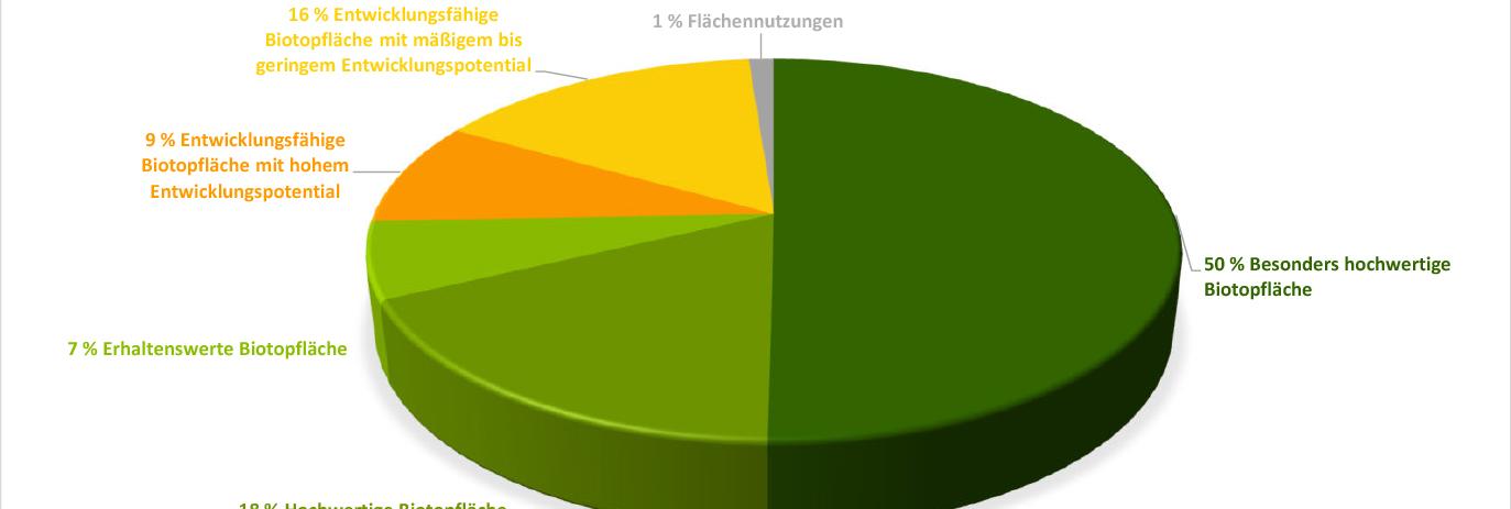
The results of the biotope mapping not only underline the high diversity of vascular plants and different biotopes, but also the high level of naturalness and nature conservation value of the biotope equipment in the Kalkalpen National Park. Half of all biotopes are classified as "particularly high-quality biotope area" and around 18% as "high-quality biotope area" (see diagram).

The ongoing evaluations of the biotope mapping serve as a basis for decision-making for management and information bases for public relations. The data can be used in a variety of ways, ranging from the creation of GIS-based maps (e.g. representation of priority FFH habitats such as ravine and slope mixed forests) to bark beetle management and the basis for presentations and scientific papers.
Current Reports & Publications
Summary of biotope mapping (final report 2015, Simone Mayrhofer)


